I was watching the sky close over a coastal ferry while the app on my phone still promised clear water and blue sky. You could see the harbor office hand radio crackle and the captain eye the clouds. I wrote down a single thought: if forecasts moved that fast, lives and businesses would follow.
I’m going to walk you through what Google DeepMind just released and why it matters to anyone who schedules, builds, or bets on the weather. You’ll get first-hand explanations, a few industry signals, and what this means for energy, logistics, and public safety.
A ferry captain once told me the weather changes between harbor and open sea in five kilometers. WeatherNext 3 claims it can show those differences hour by hour at roughly 5-kilometer resolution, and that shifts the conversation from broad warnings to neighborhood-level planning.
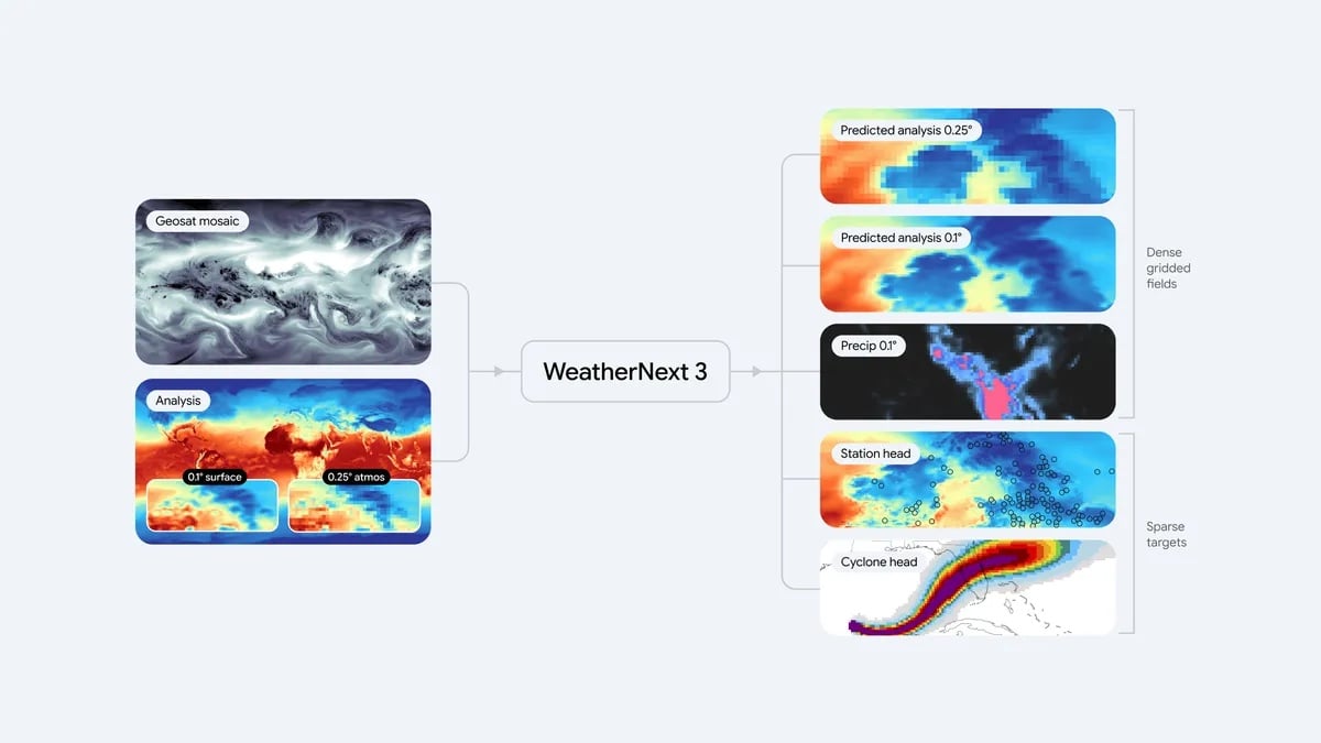
Google DeepMind and Google Research released WeatherNext 3 this week and are billing it as their most accurate global AI weather model yet. The practical change is simple: the model trains directly on hourly raw satellite imagery and sparse station readings, rather than waiting for numerical weather prediction output to trickle in.
That difference is not subtle. Traditional numerical weather prediction runs physics on observations and needs massive compute—supercomputers that can cost $10 million (€9.5 million) or more—to run detailed forecasts. AI systems have been faster but often leaned on those same physics outputs, creating roughly a six-hour lag for nowcasts. WeatherNext 3 reads the satellite feed itself, producing a fresh global forecast every hour and tightening the lag that breaks many short-term predictions.
How accurate is WeatherNext 3?
On independent leaderboards like Operational WeatherBench, run by Brightband, WeatherNext 3 sits at the top. Google claims up to 50% better precipitation forecasting one day or more ahead in many regions. For you that means fewer missed deluges and fewer surprise dry spells when planning events, transport, or crop irrigation.
A mountain town I visited had sun on one ridge and hail on the other within minutes. WeatherNext 3’s higher-resolution temperature and moisture fields can map those abrupt shifts, which is critical in complex terrain.
At 5-kilometer resolution it models surface temperature and moisture differences; at 25 kilometers it produces wind-speed forecasts. Those scales matter for coastlines, valleys, and cities where conditions change across short distances. The model also trains on sparse weather-station reports, not just the heavy analysis outputs, so it can anchor satellite patterns to real observations.
I’ve used many forecasting tools and I’ll give you a plain read: this is a move toward more actionable, location-specific weather information. One vivid image: the model treats satellite streams like a photographer focusing a lens, sharpening where it sees signal. That single approach changes how products like Google Search and Google Maps can serve instant micro-forecasts.
How does WeatherNext 3 use satellite data?
Rather than ingesting post-processed model fields only, WeatherNext 3 consumes raw, hourly satellite imagery and fuses it with conventional data. The model then predicts variables across the globe every hour. That direct feed reduces the hours-long dependence on numerical outputs and makes short-term, fast-evolving events easier to spot.
A wind farm manager once told me the day’s forecast can make or break revenue. WeatherNext 3 includes wind speed at 100 meters and solar radiation predictions, which changes day-to-day operations for renewables.
Those specific layers—cloud cover, solar radiation, and winds at turbine height—aim to help operators estimate generation more precisely. If a single forecast revision can change a bidding position in a market, an hourly refreshed, higher-resolution model is not academic; it’s financial. It’s also another example of AI moving from research labs into grid and market operations through platforms like Google Cloud and Google Earth Engine.
Operationally, Google says WeatherNext 3 will power experiences in Google Search, Gemini, Google Maps, the Google Maps Platform Weather API, and Google Earth Engine. Brightband’s Operational WeatherBench and other benchmarking efforts gave the model a competitive ranking, which matters because industry adoption often follows those independent scores.
Will WeatherNext 3 replace national weather services?
Short answer: not immediately. Google directs people to local meteorological agencies for official warnings and public-safety advisories. National services have legal responsibility and ground-level networks; WeatherNext 3 is positioned as a complement and a product for high-frequency, high-resolution needs inside Google’s ecosystem and for partners who license weather APIs.
An aid worker in Lagos told me that better forecasts change where supplies go, sometimes saving lives. WeatherNext 3 suggests those benefits could be bigger in parts of Latin America, Africa, and Asia-Pacific where high-resolution forecasts were previously scarce.
Google highlights that the model’s lower need for massive traditional compute could make high-resolution forecasting more accessible in regions where building and running supercomputers is prohibitively expensive. That has real humanitarian implications for flood warnings, heat stress alerts, and crop advisories.
Two industry tensions to watch: data independence and transparency. AI models that ingest raw satellite feeds and station data create new questions about provenance, bias, and how forecasts are verified against official records. Operational WeatherBench and other independent validators matter because they hold the system to a public standard.
I’m not handing you a verdict; I’m handing you the signals. Google DeepMind’s WeatherNext 3 is more than a press release: it’s an example of AI reading raw earth observations hourly and routing that insight into consumer and industrial tools. Another metaphor: it’s like a chess player seeing several moves ahead, turning short-term satellite cues into tactical forecasts.
You’ll see this technology in products and APIs, but you should still check your national weather service for warnings. The real story is what happens when high-frequency, high-resolution forecasts meet real-world decisions—airlines, ports, grid operators, and farmers will test whether hourly updates change outcomes on the ground.
If Google’s model keeps climbing independent leaderboards and integrations multiply across Google Search, Gemini, Maps, and the Google Maps Platform Weather API, will public trust, regulatory scrutiny, and commercial adoption follow fast enough to matter before the next storm hits?